3D Laser Scanning
 Precise, complete and safe capturing of existing conditions is becoming necessary as a foundation for engineering design and retrofit tasks.
3D laser scanning allows a trained Shambaugh designer to accurately capture, analyze, and interpret the existing conditions of complex geometries, such as industrial facilities or structural sites, in a short time frame.
Additionally, Shambaugh’s laser scanning solutions assist engineers and designers in determining tie-in points, centerlines, and/or collisions for industrial maintenance and planning, or to extract building and MEP components.
How it works:
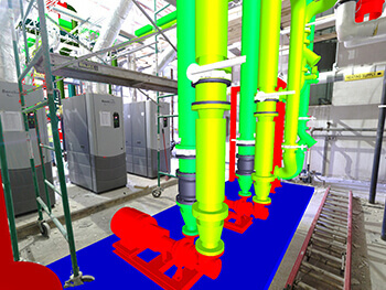
A Shambaugh laser crew performs a complete walkthrough of the project and determines strategic places to set up the 3D laser scanner. The tripod-mounted scanner initially takes high definition images that colorize the point data to provide a photo realistic point cloud.
The device then emits a laser and measures the phase shift in the returning laser to determine distance. It repeats this laser process up to 500,000 times per second, while rotating 360 degrees, to create point data. The scanner is setup in several locations, and the process is repeated until the desired subject is captured in full.
The Shambaugh design team then initiates in-office processing, which involves using computer algorithms to register each scan and stitch them together to create a project point cloud.
The result is a precise point cloud of existing site conditions which is 100% true to scale and allows for viewing, measuring, and converting into AutoCAD and other similar programs. The accuracy of the drawing is superior and can be used for fabrication without further manipulation.
3D laser scanning benefits include:
- Fast, complete, accurate field measuring (accurate to 1/8th of an inch at 230 feet away)
- Can be operated during production (no shutdown required)
- Laser is not harmful to materials, products, or personnel
- All existing site conditions are recorded
- Easily integrate new services/equipment into existing congested locations
- Allows for a virtual walkthrough of the site
- Renders high-quality photos
- Allows for a better understanding of the project
- Improved quality on installed products
- Clients can better understand the end result through augmented reality